High Nook Tarn, the Corpse Road & Loweswater

Loweswater
During the medieval period, the local population rose significantly and, consequently, so did the number of churches in the area. Keen to retain their authority and sustain revenues, senior ministers of existing parish churches made claims to burial rights over the area, thus resulting in the need for residents in outlying villages to travel a fair distance to bury their loved ones in the designated consecrated ground. Corpse roads were created to allow villagers to travel to their parish churches for this reason. One such corpse road ran from Buttermere to the church at Lamplugh, a village on the western edge of the Lake District. Part of the ancient route remains, and this walk follows it as it traverses the side of fells above Loweswater.
This route is a fairly gentle walk, with an easy climb at the start to High Nook Tarn, a secluded tarn nestled in farmland, before following the corpse road to above Loweswater. There is then a delightful descent through Holme Wood to reach the shore of Loweswater. The route is along fairly well maintained paths, and those with sturdy, all terrain pushchairs would be able to complete it, providing there are two adults to carry the pushchairs over some short sections. The area around High Nook Tarn can be boggy after wet weather, and is brimming with dragonflies during the summer.
Quick Facts
Distance: 3.5 miles
Time: 1-2 hours
Terrain: Mostly well-maintained paths; Narrow at times; Moderate ascents
Suitable For: Older Children, Younger Children with Assistance, Babies and Toddlers in Carriers, All terrain pushchairs with two adults, Dogs need to be kept on the lead during the first section
Parking: Free parking at Maggie’s Bridge Car Park (Grid Ref NY 134 210)
Facilities: None on the route; The Kirkstile Inn is a 5-minute drive from the car park
The Start of the Walk – Maggie’s Bridge Car Park

The Exit from Maggie’s Bridge Car Park
To get to Maggie’s Bridge Car Park follow the road from the village of Lorton to the village of Loweswater. Go past the turnings for the Kirkstile Inn and the Loweswater Village Hall and you will see a turning on your left with a sign for High Nook Farm. Take this turning and follow the very narrow road down to the bottom, where you will find the car park. Do not block any gates in the car park, they are all in use at all times.
This car park is very popular during the peak tourist season, so it’s best to get there early as spaces are limited to around 10-15 cars. Parking is free, but there is a donation box for the National Trust (who own the land) if you are so inclined. Once parked, head back out to the entrance of the car park and take the bridleway on the right, signposted for High Nook Farm.
High Nook Farm

The Farm Track, Looking Towards Carling Knott
You will be on a wide farm track. Go through the first large gate and follow the track through the field. Go through a second gate and continue to follow the track along a stone wall. You will arrive at a third gate that you will need to go through, and you may find cattle or sheep in this next field, so dogs must be on the lead.
Continue to follow the track up towards the farm buildings. You will come to another gate to go through, this time taking you into the farm courtyard. This is a traditional working Lake District farm, but please do bear in mind that it is also a private home. Go through the courtyard and through another gate at the other side.
The Gentle Ascent

The Path Leading Up Towards the Tarn
Beyond the gate, you will see that there is a clear path that leads up a gentle slope. Again, you are likely to encounter grazing livestock here, so please keep dogs on leads. All terrain pushchair users may struggle at times with the ascent and, if you have a toddler in one, then now is the time to convince them to walk for a bit. After a short distance, the track comes to a wall and another gate that you will need to go through. At this point, you are high enough to be treated with some picturesque views of the surrounding fells.
High Nook Tarn

The Tarn Above High Nook Farm
Beyond the gate, there is a fork in the path and you need to take the right hand fork (with the left hand fork leading up the fell). After this, the path begins to narrow. It starts to veer to your right as you drop down, but to get to the tarn, look for a worn trail through the grass heading straight on towards a small mound in the near distance.
The tarn lies beyond this mound to the left, and in drier months, it will not be visible until you are much closer. During the summer, the tarn is brimming with dancing dragonflies. This is a lovely, peaceful place to stop in the summer, but it may be boggy after wet weather.
The Corpse Road

Looking Towards Grasmoor from the Corpse Road
Head back from the tarn towards the main path and continue to follow it as it veers to the right, crossing over a small stream with stepping stones. You are now on the old corpse road. The path begins to gently rise, following the bottom of Carling Knott, and from here the views of the north-western fells are outstanding, with glimpses of the edges of Crummock Water and Loweswater between the fells. Eventually, the view becomes obscured as you reach the edge of Holme Wood. The path now runs along the top of Holme Wood, with a wall between you and the woodland.
Holme Wood

The Path Leading into Holme Wood
You will reach another gate with the option to cross over a stile. On a clear day, standing on the stile will enable you to see over the tree tops across West Cumbria, out to the Solway, with the Scottish fells in the distance. After a short distance beyond the gate, look for a small path on the right hand side leading down to the wall.
There is a small gate to go through, and once through, you will now be in Holme Wood. Follow the narrow path as it leads down through the wood. At the end of the path, you have the option to turn left or right, with both leading down to the lake, and both around equal distance. For this route, turn left.
Loweswater
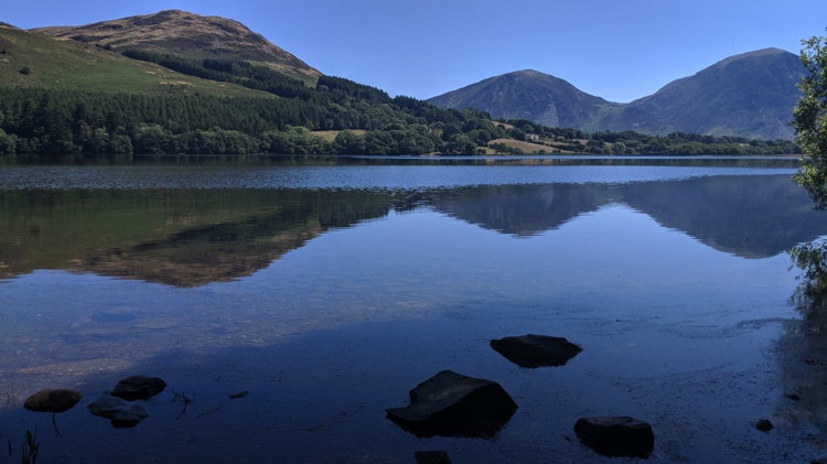
Loweswater
You will now be on a much wider forestry track. This leads through the forest, down towards the National Trust Bothy and the shore of Loweswater. There are small footbridges to cross, plenty of trees to climb, and a tree swing near the bothy. There are places along the shore that are ideal for picnic spots.
At the bothy, veer right along the track so that the lake is on your left. You will come to gate that takes you out of the woodland. The track now continues through open fields, until it ends at the Maggie’s Bridge car park.